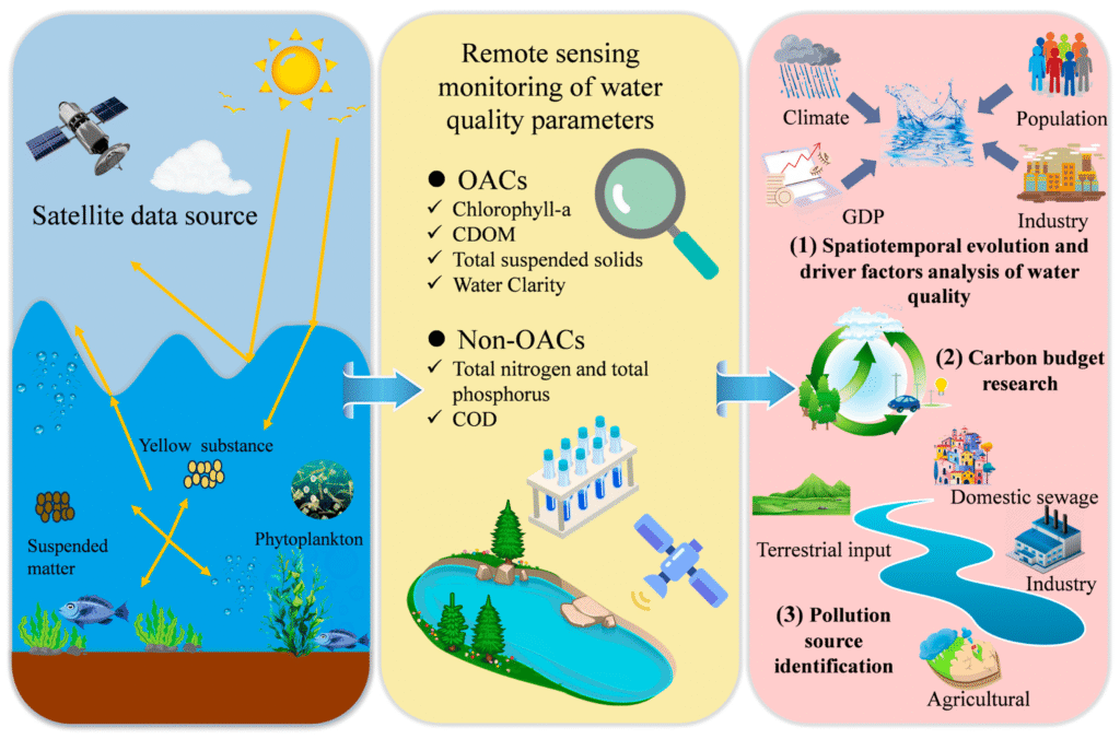
New satellite missions combined with advanced artificial intelligence (AI) technologies are revolutionizing the detection and monitoring of methane emissions and soil contaminants, significantly enhancing climate and environmental oversight. These innovations are empowering scientists, policymakers, and industries to better understand, quantify, and mitigate environmental pollutants that contribute to climate change and ecosystem degradation.
Enhanced Methane Emission Detection with Satellite and AI Integration
Methane is a potent greenhouse gas with a global warming potential over 80 times greater than carbon dioxide over a 20-year period. Detecting and quantifying methane emissions accurately has historically been challenging due to the gas’s dispersed sources and the limitations of traditional monitoring methods. However, new satellite missions like MethaneSAT, launched by the Environmental Defense Fund, utilize advanced remote sensing technologies to measure methane pollution from oil and gas facilities globally. MethaneSAT aims to reduce methane emissions from this sector by 75% by 2030 by providing detailed basin-wide emission maps and pinpointing superemitter sources, thus enabling targeted mitigation efforts.
The integration of AI with satellite data further enhances the precision and speed of methane detection. AI-driven systems employ deep learning architectures such as CNN-GRU and LSTM models to analyze complex spatial and temporal data patterns from multiple sources, including Sentinel-5P satellite data, climate reanalysis datasets, and geospatial intelligence platforms like OpenStreetMap and Google Earth Engine. This hybrid multi-source fusion framework improves anomaly detection, quantification accuracy, and source localization with classification accuracies exceeding 92% and significantly reduced prediction errors.
Companies like Zefiro Methane Corp. are leveraging AI-powered satellite imaging combined with blockchain technology to identify and seal orphaned and abandoned oil and gas wells that leak methane. Their partnerships with tech firms Geolabe and Keynum have developed AI dashboards that prioritize wells for repair by predicting significant methane leaks, accelerating cleanup efforts, and facilitating carbon credit certification. This real-time monitoring capability, enhanced by drones equipped with infrared cameras and automated data analysis systems, is transforming methane abatement into a faster, smarter, and more cost-effective process.

AI Accelerating Methane Mitigation Strategies in Agriculture
Beyond fossil fuel sources, livestock agriculture is a major contributor to methane emissions, primarily through enteric fermentation in ruminants. AI is playing a pivotal role in fast-tracking mitigation strategies in this sector. For example, USDA Agricultural Research Service and Iowa State University scientists have used generative AI to identify compounds that inhibit methane production in cows’ rumens, potentially reducing methane emissions from animal agriculture significantly.
Broader Environmental Monitoring: Soil Contaminants and Pollution
AI and satellite technologies are also advancing the detection of soil contaminants and other environmental pollutants. By combining AI with Internet of Things (IoT) sensors and edge computing, environmental monitoring systems can perform real-time analysis of soil and air quality data at the source. Hybrid models that integrate physics-based simulations with machine learning improve the identification and prediction of pollution sources, enabling proactive environmental management.
Furthermore, AI-guided robotics are being deployed for autonomous pollution cleanup, while blockchain ensures transparency and traceability in environmental data collection. Mobile applications powered by AI enable decentralized citizen science efforts, broadening data collection and environmental awareness.
Impact on Climate and Environmental Policy
The unprecedented granularity and accuracy of methane and pollutant data generated by these technologies support stronger regulatory frameworks and more effective climate mitigation initiatives. Platforms like the International Methane Emissions Observatory (IMEO), led by UNEP, leverage AI to create global public databases of verified methane emissions, fostering transparency and data-driven policymaking. Publicly accessible satellite data from missions like MethaneSAT and Carbon Mapper empower independent monitors and stakeholders to hold emitters accountable, increasing pressure to reduce emissions.
Conclusion.
The synergy of new satellite missions and AI technologies is transforming environmental monitoring by enabling precise, near-real-time detection and quantification of methane emissions and soil contaminants. These advancements facilitate targeted mitigation strategies, accelerate cleanup efforts, and support transparent, data-driven climate policies. As these tools continue to evolve and scale, they represent a critical frontier in the global effort to combat climate change and protect environmental health.

